By Shaul Arieli | June 2005
(Available for download here)
The ninety-nine papers and proposals formulated during the twentieth century regarding the future of Jerusalem(1)
testify to the importance of the city for Judaism, Christianity, and Islam - and to the ongoing battle of interests
being waged between the diplomatic and political representatives of these three religions. Each of the proposals
considers the local and global balance of power in the boundaries of the city and attempts to ensure freedom of
worship and internal management of the holy places.
The major issue of contention regarding political control of Jerusalem was and is the Temple Mount. It seems that
for the extremists of all three religions any arrangement is regarded as a temporary one, until the conditions
ripen for a realization of the spiritual ideal. Over the last decades the religious tensions already evident in the
city were intensified by the nationalist tensions of the Israeli-Palestinian conflict, which were aggravated by the
sides themselves and even by additional groups in the Muslim and Christian world.(2)
In addition to claims to the holy sites, a large part of the Israeli public regards a unified Jerusalem in its
present borders as a single entity and opposes its partition.(3) This position was formalized in the mythical
status awarded to these boundaries as a result of the legislation, "Jerusalem: The Capital of Israel, 1980."
Against this Israeli attachment to the idea of a unified Jerusalem lie Palestinian religious and nationalist claims
to the city. Are the State of Israel and the Jewish nation thus inevitably called on to partition Jerusalem and
yield its holy places in order to overcome one of the substantive obstacles to an end to the conflict with the
Palestinians, or might perhaps a solution to the question of Jerusalem's boundaries lie in their
redefinition?
Indeed, the regional conditions created as a result of the diplomatic process between Israel and the Arab world may
permit the establishment of a diplomatic solution in Jerusalem between the Palestinians and the State of Israel,
based on the status quo in the holy places. In envisioning a practical solution for both sides, this essay will
define the boundaries of Jerusalem through two stages. The first stage offers a model for temporary management of a
unified Jerusalem, which considers Israel's security needs, the fabric of Palestinian life in East Jerusalem and
the West Bank, and the need for the sides to resume negotiations. This represents an interim solution until a
permanent agreement on Jerusalem is achieved. In a final settlement, because of the overlap between the religious
significance and the administrative control in most of the sites, a territorial solution must based as far as
possible on adapting the diplomatic status to the religious status of the holy places. To this end, the essay
proposes a different kind of organization of the sites. Finally, the remaining area of the city should be defined
in accordance with the criteria formulated during previous negotiations and summarized in the Clinton proposal of
December 2000.
A Unified City?
Jerusalem, crowned the capital of the kingdom of Israel after its conquest by King David circa 1000 BCE, remained
under Jewish political sovereignty for nearly 500 years and religious control for slightly more than 1000 years.
Its initial area was approximately eight and a half to ten acres. By the end of the Second Temple period, in the
year 70 CE, Jerusalem reached new heights in development, expanding to about 550 acres; municipal boundaries of
this magnitude resumed only in the mid-nineteenth century. Since the era of King David and throughout the
millennia, Jerusalem has served as a symbol of Jewish identity and Jewish heritage. Once Christianity was declared
the official religion of the Roman empire, the city as a whole and specific churches in particular acquired
religious significance for the Christians. The Muslims sanctified Jerusalem shortly after their conquest of the
city in the seventh century. Although they never declared it a capital city of any kind, they enjoyed religious and
political control over it for almost 1400 years. The areas of religious and historical significance for Judaism,
Christianity, and Islam are spread out over less than 500 acres, and comprise only 1.5 percent of unified
Jerusalem's 32,000 acres.
The 1948 War of Independence left Jerusalem's Old City without Jewish residents and under Jordanian rule for
nineteen years(4), until Israel conquered East Jerusalem and the entire West Bank and redrew the boundaries of the
city. Regarding the holy sites in Jerusalem, the Israeli military government decided to maintain the status quo.(5)
The Christians were given de facto sovereignty over the Church of the Holy Sepulchre and parts of the Christian
Quarter of the Old City. Most of the Temple Mount was left in Muslim hands, and Jews were granted free access to
the Western Wall and to the walls of the Temple Mount. Jews were permitted to visit the Temple Mount but not to
pray there. In addition, no flags bearing symbols of sovereignty were raised in the precincts of the Temple Mount.
As to the legal status of united Jerusalem(6), the majority of the international community has accepted Israeli
control of the western part of the city but not the eastern part.(7) Although Israeli authorities regard the
eastern portion of Jerusalem as part of the State of Israel,8 the international community has rejected this
approach.(9)
The extension of Jerusalem's jurisdiction in 1967 was not undertaken according to protocol, with the minister of
the interior setting up a commission of inquiry and holding an ordered discussion on the matter, but by an
amendment to the "order for arrangements of rule and law" of September 1948, whose wording (clause 11b), permitted
completion of the "unification" seventeen days after the end of the war. The order, published the following day by
the government secretariat, specified a municipal line that did not appear on a map but referred to imaginary lines
between points of reference. In no place in the judicial proceedings does the name of Jerusalem appear, and the
government's desire to hide and blur the annexation, out of fear of a grave international response, is
evident.
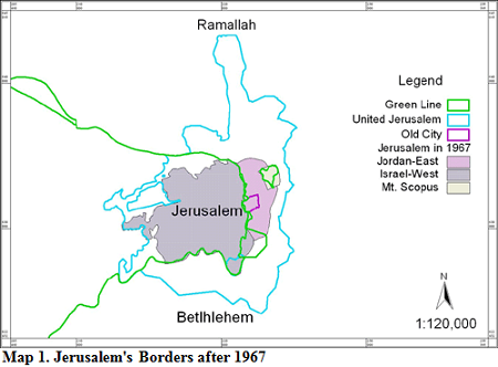
In essence, there were five major principles that determined the new boundaries of the city.(10) The first and most
important principle was demographic-territorial: annexing extensive areas to Jerusalem in order to ensure its
expansion and development, while avoiding inclusion of densely populated refugee camps and Arab villages within the
precincts of the city. In practice, the total area annexed to Jerusalem came to 17,500 acres, of which only about
1500 acres were Jordanian Jerusalem. The rest of the area belonged to twenty-eight villages, a small number of
which were annexed in full and the rest in part (map 1). The number of Palestinians who overnight became residents
of Jerusalem and the holders of Israeli identity cards was 69,000, representing 23 percent of the population of the
unified city. The annexation, intended to allow for the construction of Jewish neighborhoods that would thwart any
attempt to repartition the city(11), resulted in the expropriation of 5,250 acres of the area annexed, but the
remaining area was rapidly filled with a Palestinian population. The number of Palestinian residents is currently
231,000, representing 33 percent of the unified city population. The number of Jews living in the ten Jewish
neighborhoods of the post-1967 addition is 179,000, representing 40 percent of the Jewish population in the entire
city.
The second principle was to separate Jerusalem economically from its West Bank environs. In practice, however, East
Jerusalem has remained the urban and economic heart of the West Bank. The largest population in the West Bank,
about 800,000 Palestinians, is concentrated in East Jerusalem and its suburbs, and significant economic activity is
also present in the area.
The third principle was strategic/security oriented. Since those dealing with the subject were convinced that the
boundaries they drew would be the borders of the state in the near future, they included a significant portion of
the hilltops surrounding Jerusalem. In practice, over the years Israel built new neighborhoods on these hilltops -
Ramot Alon and Ramat Shlomo in the north and Gilo in the south - so that today Mount Gilo in the south, Nebi Samuel
in the north, and the outer heights of Ma'ale Adumim in the east, outside the boundaries of the annexation, are
those commanding the city that has expanded.(12) In the Camp David negotiations, the Palestinians accepted the
demilitarization of their future state and its independence of a foreign army and heavy weaponry. As such, Israel's
security needs are reduced to defense against terrorism, which does not obligate the annexation of the Palestinian
areas to the city, and certainly not the areas outside the city protected by the security barrier. In fact, the
very removal of densely populated Palestinian regions from the boundaries of the city will only alleviate the
security solution required for daily life in Jerusalem.
The fourth principle was to include within the city boundaries important facilities such as the Atarot airport, the
slaughterhouse in Shuafat, and the cemetery in the Mount of Olives. In practice, the airport is currently not being
used nor is it needed, the slaughterhouse has ceased operation, and few burials take place on the Mount of Olives,
although the site retains religious and historical significance.
The fifth principle was to consider ownership of land and previous land arrangements. In practice, areas that lay
within the boundaries of the municipalities of Bethlehem, Beit Jalah, and El Bireh were annexed as part of the
5,250 acres of Palestinian land and expropriated for the construction of Jewish neighborhoods. Although according
to the 1950 Israeli law on abandoned assets the government could have expropriated the land and private property of
the Palestinians, it avoided this measure. However, to advance construction of the separation fence, on April 8,
2004, the Israeli government authorized the expropriation from their legal owners of private property valued at
millions of dollars, without right of appeal.(13) In negotiations between Israel and the Palestinians in the Taba
talks of January 2001, which were based on the Clinton proposal of December 2000, understandings were reached that
the Jewish neighborhoods would remain under Israeli sovereignty in a final settlement.
Herein lay the five principles that governed the idea of the expansion of the city. Despite thirty-eight years of
"unification," however, Arab East Jerusalem is de facto separate from the western part of the city and from the
Jewish neighborhoods in the east.(14) Infrastructure standards are entirely different: 50 percent of East Jerusalem
is without water mains and drainage systems, and 50 percent of East Jerusalem lands have no detailed and approved
zoning plans, which makes the planning of roads and infrastructures and the provision of construction permits in
accordance with zoning plans difficult at best. Despite the virtually unrestricted access by Arab labor to the
Jewish employment market in Jerusalem, the reality is two sectoral employment markets in the two parts of the
city.(15) The same applies to the transportation and education systems.
Only 6,000 people, a small percentage of Jerusalem's Arab population, exercised the option of acquiring Israeli
citizenship in addition to their status as Israeli residents. The Palestinians pay taxes and enjoy the services and
benefits given to all Israeli residents, but in actuality they only apply to the state authorities when they have
no alternative. They boycott the municipal elections, and those who have another address outside Jerusalem voted in
the elections for the chairman of the Palestinian Authority and the Palestinian Legislative Council held in January
1996, and in the elections for the chairman in January 2005.
This reality and the progress in the negotiations at the Camp David summit in July 2000 dictated Clinton's proposal
for a final settlement. Clinton's approach departed from the traditional American position that regarded new
municipal administrations and new Jewish Jerusalem neighborhoods as temporary measures that would not affect the
current or future status of the city in negotiations for a permanent settlement.(16) Clinton proposed partitioning
the city according to the principle that Arab areas are Palestinian and the Jewish ones are Israeli. This principle
would similarly apply to the Old City. The Israeli and Palestinian delegations accepted this proposal and advanced
towards a solution in the Taba talks,(17) and the unofficial Geneva accord, concluded in October 2003, draws a
border that incorporates the specific proposal of the president (map 2).(18)

The collapse of the political process following the Camp David summit led to a norm of violence in which both sides
felt betrayed and without a "partner" for negotiating an acceptable solution. Moreover, public pressure reacting to
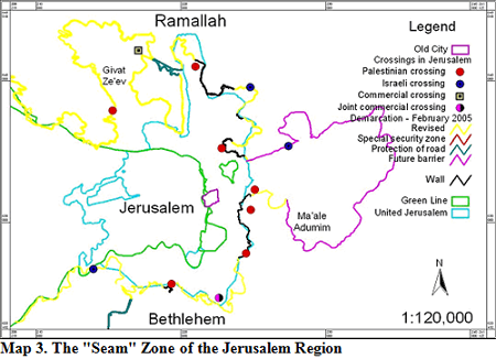
the violence and terrorism of the intifada propelled the Israeli government to set up a "seam" zone and security
fence, including around Jerusalem. The route approved by the government in June 2002 and in October 2003 intended
to expand Jerusalem's boundaries with an additional security region. All the hilltops commanding Jerusalem and
located outside its boundaries have been included in the seam region: Mount Gilo in the south, which also overlooks
Bethlehem and Beit Jalah, and Nebi Samuel and the Sheikh Zeitun range in the north, which also dominate Betunia and
Ramallah.
The Israeli government decided to include the geographical area annexed in 1967 and additional territories in the
seam zone, but did not fully integrate the populated areas or provide infrastructures and services comparable to
Israeli areas.(19) The fence under construction effects a substantive change in the ways of life of the Palestinian
population in the eastern part of the city and the Jerusalem metropolitan area. The 200,000 Palestinians who will
live between the fence and the Green Line will be obliged to develop new routines, as will those who will live on
the eastern side of the fence, but this will not obviate the Palestinian demand that East Jerusalem be the capital
of the future state. The ruling of the Supreme Court in June 2004 in the petition submitted by residents of the
Palestinian village of Beit Surich, joined by residents of Mevasseret Zion and the Council for Peace and Security,
forced the Israeli government in February 2005 to approve an alternative route for the fence that balances Israeli
security with Palestinian lifestyle needs. This new route will reduce slightly the amount of Palestinian land
separated from its owners and the number of Palestinians on the western side of the fence, but it does not
substantively mitigate the separation of East Jerusalem from the Palestinian population of the West Bank (map
3).
Despite its ostensible unification, therefore, the city functions essentially as two separate capitals, of Israel
and of the Palestinians in the West Bank.(20) All five principles that led to delineating the boundaries of the
city in 1967 are no longer relevant, either because of the failure of their aims, such as the detachment of East
Jerusalem from the West Bank, or because of the political developments that obviate the need for defense against a
regular army.(21) Even with any changes to the demarcation of the security fence, the fabric of life of the
Palestinian residents of East Jerusalem and the West Bank will be seriously harmed after the completion of the
fence. Additional measures by the Jerusalem municipality, such as the intention to construct Jewish neighborhoods
in the heart of the Palestinian population, are liable to complicate the feasibility of separation on a demographic
basis that currently still exists in Jerusalem.(22)
If so, and on the understanding that the annexation and the construction of the new Jewish neighborhoods did not
succeed in dissuading the Palestinians from striving to establish their capital in the eastern part of the city,
there must be a different approach to the challenge of Jerusalem. First, an interim period is necessary to effect
the transition from a "unified" city into the two capitals of two states. In the second stage, the holy sites must
be organized anew in order to fuse the religious and political interests in a permanent solution for Jerusalem. The
validity of the solution in the second stage will rest on its acceptance by both sides as part of a permanent
settlement, and it will be realized only as part a comprehensive permanent solution, in order to prevent the
stronger side from imposing any dominance it enjoyed in the interim agreement.
The Period of Transition
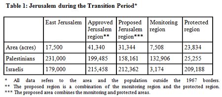
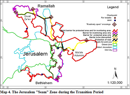
At the core of interim period proposal is a narrower seam zone. Map 4 and table 1 depict this proposal, which
ensures the security needs of the Jewish neighborhoods in the eastern and western parts of the city and preserves
the fabric of life of the Palestinian population in Jerusalem and the greater metropolitan area. Significantly, the
proposal does not call for changing the legal status of the city and its residents and does not affect the social
services they are entitled to. The following principles underlie the proposal for a more limited seam zone:
1. Ongoing IDF, General Security Services (GSS), and Israeli police operations on both sides of the security
barrier, until an agreement is reached between the sides. 2. Security of the Israeli neighborhoods in Jerusalem in
a protected region separate from the Palestinian neighborhoods.(23) The form of separation will be based on a
different profile than the existing one. It will be possible to incorporate a decorative electronic fence or
maintain a separation based on the existing topographical route. 3. Contiguity between Jerusalem and the large
Israeli residential areas in the metropolitan area (Ma'ale Adumim and Givat Ze'ev) and their inclusion in the
protected region. 4. Creation of a system of crossings that will permit entrance by Israeli residents - Israelis
and Palestinians - into the Israeli protected region (exit from it will not be controlled). 5. Retention of most of
the existing barrier with seven crossings that will be "routinely open" for Palestinian needs and Israeli traffic
bypassing Jerusalem, while maintaining security through random checks or absolute control, subject to the current
security assessment. This barrier will create a region for preliminary monitoring of terrorist activities before
they reach the protected region. 6. Maintaining access by both populations to the sites holy to the three
religions.
For example, a Palestinian bearing a Palestinian Authority identity card may leave the bloc of villages to the
south of Highway 443 (on the Modi'in - Givat Ze'ev road), drive on the road, enter the monitoring region near Beit
Horon at a point that is "routinely open," cross, and leave for Betunia in the region of the Ofer refugee camp at a
similar point. Alternatively, he may reach the Palestinian neighborhoods in northern Jerusalem, Shuafat and Beit
Hanina, and cross to the east and the south under a bridge in the region of the Shuafat refugee camp without being
delayed. The entry to the monitoring region will be controlled and modified by Israeli security forces based on
security evaluations. If he is also authorized to enter Jerusalem he may use one of the three following crossings:
Bidu in the north, "Checkpoint 300" near Rachel's Tomb in Bethlehem in the south, and Mount Scopus in the east. An
Israeli who does not wish to enter Jerusalem may use the same route and continue to the Jordan Valley or the Dead
Sea without delay. Entry to the city itself will be through the checkpoints for Israelis (map 4).
On the assumption that the Israeli government and the PLO can end the conflict only through resuming negotiations
on a permanent settlement, this proposal enjoys the following advantages:
• The security for Jerusalem's Jewish neighborhoods is improved, because they are included in a protected region
without a Palestinian population that participates in the Palestinian struggle.
• The legal status of the city and of its residents is not harmed and the Palestinian residents will continue to
enjoy municipal services, social security payments, and other institutional services. However, if the Israeli
government coordinates with the Palestinian Authority, it will be possible to transfer the neighborhoods in whole
or part to Palestinian responsibility with the status of Area B.
• The Israeli and Palestinian routines in the Jerusalem region and in the city itself will be preserved in their
present alignment - the western part of the city and the Jewish neighborhoods with the State of Israel, and the
Palestinian neighborhoods with the West Bank. This will halt the increasing tendency of the emigration of
Palestinian holders of Israeli identity cards into Israel,24 as well as the decrease in the standard of living in
East Jerusalem, an economic reality that provides fertile ground for terrorist organizations to recruit new
operatives.
• In physical terms, the proposal can be feasibly implemented and does not delay the completion of the fence
approved by the government.
• The proposal permits postponing the specific political argument regarding the boundaries of Jerusalem because it
preserves the municipal status quo, although some people will claim the exact opposite, since the boundaries of the
protected region are determined on a demographic basis.
• The proposal provides a political channel for the solution of the conflict without obstructing implementation of
an agreement based on the Clinton proposal.
• The proposal includes a saving of hundreds of millions of shekels in the construction of crossings in the
security fence required for preserving the Palestinian fabric of life.
There are those who oppose the very foundation on which this proposal is based - partition of Jerusalem in
accordance with Clinton's proposal. In addition, the proposal includes certain shortcomings:
• Opposition from the Israeli Right for the demarcation of a political route based on a demographic line that
excludes the City of David and the Mount of Olives from the Israeli area.
• Opposition from the Palestinian residents of the city for the control of their passage between the eastern and
western parts of the city.(25)
• Palestinian criticism on Israel's capacity to close the monitoring region to the Palestinian population in Judea
and Samaria.
• Increase in construction and operating costs of the barrier, which will essentially depend on two systems
(notwithstanding the savings specified above).
• Reduction of the time and space for terrorist penetration from Judea and Samaria into the western part of the
city, because of the "routinely open" concept of the entrances to the monitoring region partially bordering on the
protected region.Overall, however, it appears that this proposal is not only viable, but will lay the groundwork on
both sides in terms of routine and public opinion for a redefinition of "unified" Jerusalem as two capitals for two
independent states.
The Permanent Solution: Proposal for the Historical Area
A permanent solution on Jerusalem will necessarily include a settlement for the area of historical significance,
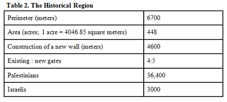
which includes and extends beyond the Old City boundaries. Map 5 depicts the region containing the holy sites,
consisting primarily of religious institutions and cemeteries. Some of this region is physically bounded by the
Ottoman walls built at the beginning of the sixteenth century, which in themselves do not have any kind of sanctity
that requires factoring them in as an exclusive criterion.
Construction of new walls around the designated region, without harming the existing walls,(26) will lead to a
physical distinction between the holy places and the rest of the city (map 5 and table 2). The walls will be
constructed as a joint project among Israelis and Palestinians. Their underlying concept will be to designate a
region for joint use rather than announcing a divisive boundary, although with a capacity for separation from the
greater urban area based on existing architectural solutions.(27) It is possible that within the walls will be
included sites for transportation, culture, commerce, entertainment, museums, exhibits, and so on, important for
members of the three religions living in the city. This physical separation will permit implementation of the model
of an "open city," proposed in the Geneva accord for the Old City only, for the entire region. Although sovereignty
over the region will be formally divided between the parties in accordance with the Clinton proposal, there will be
no physical obstacles, and in practice the status quo will be preserved in all sites sacred to the three
religions.
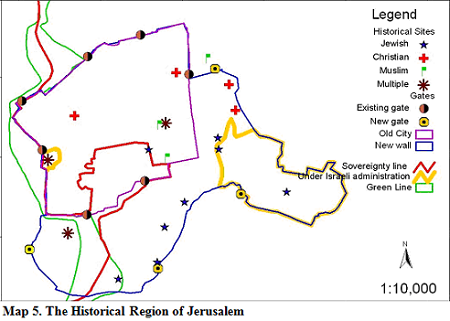
Application of the model of the open city to the proposed area in addition to the Old City is fair to both sides.
Israel will implement the special regime on Mount Zion and the Palestinians on the City of David and the sites in
the Kidron Valley. No change will occur to the special status of the Jewish cemetery on the Mount of Olives and
David's Citadel, which will remain under Israeli administration. All the special arrangements required in order to
ensure freedom of religious worship in sites outside the Ottoman walls will be preserved.
A Jewish Israeli wishing to visit an area under Palestinian sovereignty will enter through one of the four gates
under Israeli sovereignty, and can visit the City of David, for example, without a passport or any organized
ferrying shuttle, and will return in the same way. The same applies to a Palestinian Christian who wishes to visit
a church on Mount Zion or a Muslim Palestinian wishing to visit a Muslim cemetery there. A resident of Silwan in
the City of David will not be required to go around the Old City in order to enter the market in the Muslim Quarter
via the Lion's Gate, but may do so easily via the new southern gate leading to the Dung Gate. All the details
related to traffic, residency, municipal services, and security will be a function of joint jurisdiction.(28) The
private purchasing procedures will be identical in the matter for the entire territory of the Palestinian state and
the State of Israel. It is possible, subject to the agreement of both sides, that the coordination between the two
municipalities regarding joint management of the region will include the option of the continuation of residence by
Jews in areas under Palestinian sovereignty, such as the City of David, or the opposite (map 5). The remaining
municipal area of unified Jerusalem will be divided on the basis of the Clinton proposal, while establishing the
border arrangements at the crossings to be constructed, based on the existing and planned system of roads.
Conclusion
The proposal provides practical and fair resolutions to the religious and nationalist tensions between Israel and
the Palestinians that harbor particular intensity regarding Jerusalem. The details of the proposal are based on a
win-win concept and not on a zero sum game. The solution does not blur the division of sovereignty and thus
prevents incentives for violation of the agreement by attempts to impose any fait accompli.
Adoption of this proposal will permit overcoming one of the major obstacles to a permanent settlement between the
sides. Once peace will be reached between the sides, it will be possible to extend the model to additional areas in
Jerusalem or to other places, without constructing a physical barrier.
________________________________________
1. As listed by Ruth Lapidot, Moshe Hirsch, and Devorah Hausen in their book Jerusalem - Where To? (Jerusalem
Institute for Israel Studies, 1999).
2. See A Review of Positions in Peace Settlements for Jerusalem (Teddy Kollek Center for Jerusalem Research,
Jerusalem Institute for Israel Studies, 2000).
3. Although since May 2000 more Israelis have agreed to partition, and the dispute is about the extent of the
division.
4. The Jordanians violated their commitment regarding freedom of access to the holy sites and desecrated the Jewish
cemetery on the Mount of Olives.
5. The founders of political Zionism were aware of the sensitivity of the holy places in Jerusalem. Herzl supported
internationalization of the holy places, and Weizmann opposed including the Old City of Jerusalem in the Jewish
state.
6. Jerusalem: Legal Aspects, (Jerusalem Institute for Israel Studies, 1999).
7. UN Security Council Resolution 242, November 1967, demands Israeli withdrawal to the 1967 borders, which include
the western part of the city only.
8. According to the law "Jerusalem, the Capital of Israel, 1980," which repeated the law for amendment of the order
for arrangements of rule and law (No. 11), 5727-1967.
9. Just as it did not recognize the Jordanian annexation in 1950.
10. Anna Hazzan, The Boundaries of Jurisdiction of Jerusalem 1948-1993 (Jerusalem Institute for Israel Studies,
1995).
11. Ibid.
12. They are all currently included or planned within the region of the security fence.
13. Meron Rappoport, Ha'aretz, January 22, 2005. Execution of this decision has been suspended by the
attorney-general.
14. As described by a study group on Jerusalem, Peace Settlements for Jerusalem (Teddy Kollek Center for Jerusalem
Research, Jerusalem Institute for Israel Studies, 2000).
15. Virtually no Arabs from East Jerusalem are accepted for work in hi-tech, and employment is limited primarily to
textile, metal, footwear, and stone industries.
16. As voiced, for example, in speeches by Ambassador Arthur Goldberg at the UN General Assembly (1967), and by
Ambassador Charles Yost at the Security Council (1969).
17. See Gilad Sher, Just Beyond Reach: The Israeli-Palestinian Peace Negotiations 1999-2002, ed. Rami Tal (Tel
Aviv: Yediot Ahronot, 2001), and Shlomo Ben Ami, A Front without a Rearguard: A Voyage to the Boundaries of the
Peace Process, ed. Rami Tal (Tel Aviv: Yediot Ahronot, 2004).
18. As Clinton acknowledged in December 2003 in a meeting with those who initiated the Geneva understandings.
19. Ya'akov Garv, The Separation Fence and the Jewish Neighborhoods in Jerusalem (Florsheimer Institute for Policy
Research, November 2004).
20. A noteworthy statistic, published by the Jerusalem Institute, in Alternatives for the Route of the Security
Fence in Jerusalem, December 2004, indicates that the number of daily crossings of the municipal boundary was
thirteen times as great as the number of crossings of the demographic boundary.
21. For an additional analysis see Moshe Amirav, "If we don't partition Jerusalem, we shall lose it," Ofakim
Hadashim no. 17 (January 2005).
22. The Kidmat Zion neighborhood in Abu Dis, the Nof Zion neighborhood in Jabel Mukabar, the neighborhood in Wadi
Joz, and others.
23. Based on the proposal of the Council for Peace and Security.
24. For example, from A-Ram only, which has a population of 63,000, 5,000 have already moved to Israel in the last
two years.
25. Although in practice, partial control is already taking place today by means of portable roadblocks set up by
the police and the IDF.
26. These belong, as part of the Old City, to the list of the world cultural assets compiled by UNESCO.
27. Yehuda Greenfeld, Keren Li-Bracha, Aya Shapira, Terminal on Border, Final project in the faculty for
architecture and town planning, Technion, Haifa, 2004.
28. As outlined in article 6 of the Geneva accord.